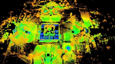
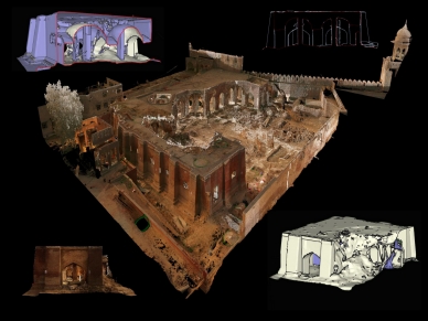
Decisions about historic conservation require a deep understanding of structure, possible only with architectural documentation, structural analysis and archival research. New scanning technologies can help organisations manage and preserve historic sites by providing engineering drawings and accurate maps to assist in critical conservation work and active management. Surveying sites, which used to take a team of researchers weeks, can now be captured in 2-3 days and an accurate high definition 3D surface model can be developed through powerful algorithms.
Delhi, India: 3D laser scanning and the Nizamuddin Urban Renewal Initiative
In Delhi, prior to the restoration of Humayun’s Tomb and Sunder Nursery, the Aga Khan Trust for Culture used 3D laser-scanning and drone photogrammetry to produce highly detailed, colour-accurate models, providing vital information that mapped all structural damage, defects and deformities. Laser beams were bounced off the building to create an accurate and complex data set, which was then used to create solid 3D models and accurate 2D drawings. This was the first instance in which laser scanning technology – which was originally invented to detect leaks in nuclear plants – was employed for conservation work in India.
aktc-india-laser_scan-ht-gardens_2.jpg

All buildings in the Complex were documented using 3D laser scanning, and transferred to AutoCAD (a computer-aided design software that architects, engineers, and construction professionals rely on to create precise 2D and 3D drawings), demonstrating the true shape of the dome, and other features of the monuments. This allowed a detailed assessment including a stone-by- stone inspection of the entire façade – wherein every stone was individually recorded, its condition analysed and its specific repairs planned.
Lahore, Pakistan: Digital tech and the 400-year-old Picture Wall
The Picture Wall is one of the principal features of the Lahore Fort UNESCO World Heritage Site. Built approximately 400 years ago during the Mughal era, it is one of the largest murals in the world. The 460-metre long monument has angels, demons, dragons, fairies, animals and humans depicted on it to show the glory and pre-eminence of the Mughals when they were at the height of their empire. In May 2019 the conservation of its 73-metre-long western facade – aided by contemporary digital documentation techniques including 3D laser scanning and drone photogrammetry – was completed by the Aga Khan Trust for Culture in collaboration with the Walled City of Lahore Authority.
aktc-pakistan-lahore_fort_royal_kitchens_3d_laser_r.jpg

The Wall’s historic architecture is being juxtaposed with contemporary technology in a region where such a combination is rarely found. This project portrays how an intricate Mughal monumental complex is documented from the macro perspective right down to its finest micro details, using survey equipment such as Electronic Distance Measuring (EDM) total stations, 3D laser scanning and drone photogrammetry. Simply explained the tracing is now done by a laser pointer emitted from a machine that a surveyor directs. These extracted point cloud and wireframe sections and plans help architects to better understand the historical building materials and construction techniques. As a result, they can formulate more appropriate and authentic intervention proposals. The surveying is done by a local team trained by the Trust’s country affiliate, the Aga Khan Cultural Service-Pakistan. Such an opportunity has allowed a deeper social impact to be created in the local sphere for marginalised individuals.
aktc-pakistan-restored-western-facade-of-picture-wall-in-the-conext-of-lahore-fort_r.jpg

Latest On AKDN


